EMAIL sent today to Nuclear@environment-agency.gov.uk
Dear Alan McGoff,
I would like to attend the meeting with the Environment Agency Regulators and officers to be held using MS Teams on Thursday 23rd May from 3.30pm to 5.00pm.
I am writing on behalf of LAND (Lakes Against Nuclear Dump – a Radiation Free Lakeland campaign) and strongly agree with the points for discussion made by Irene Sanderson:
1 The nuclear waste Hinkley Point and other future nuclear power generators will generate
I see from the 6 May edition of the Daily Telegraph that there are plans to deal with the nuclear waste by digging a huge cavern under the Irish Sea. This attitude to nuclear waste, that it is something that may be squirrelled under the carpet for future generations to cope with, is a disgrace and indeed utterly immoral. And the first steps we must take are to stop making nuclear waste and stop making it now.
2 Products for Nuclear weapons
We must wake this country up out of its ‘nuclear dream’ and face its nightmare, nuclear war. The nuclear bomb is the bedrock of Britain’s security, an unethical and impossible threat that is dependent on the technology of the nuclear industry for its upkeep and development. So Hinkley Point will play its role in this as well as being essential in providing the raw ingredients for the nuclear warheads.
On behalf of LAND I would like to make further points for discussion and ask the Environment Agency the questions below:
I live near Kendal which is within the Sellafield Outline Emergency Planning Zone to be enacted in “exceptional circumstances” of an accident or incident at Sellafield.

Sellafield have recently carried out a Site Earthquake Liquefaction Assessment which would be an “exceptional circumstance.”
“Liquefaction is an earthquake hazard, which occurs predominantly in loose saturated fine-grained non-cohesive soils such as silts and sands. The excesspore pressure, generated in such a soil by intense ground shaking, can cause large ground deformations or even soil failure due to its loss of stiffness and shear strength. Damage to constructed works caused by the complete loss of soil strength associated with liquefaction varies from minor settlement-induced cracking to complete failure of entire geotechnical systems (building foundations, dams,etaining walls, etc.).” Sellafield Site Earthquake Liquefaction Assessment published in THE SOCIETY FOR EARTHQUAKE AND CIVIL ENGINEERING DYNAMICS newsletter October 2022. Essentially the ground acts like a liquid.
In the UK the ONLY liquefaction event recorded was in 1865 at the village of Rampside near Barrow in Furness coinciding with the era of mass void removal at the nearby Hodbarrow Mine the largest iron mine in the world at that time. The mine was relatively shallow at its deepest, only 600ft. There are disagreements as to how low the magnitude of earthquake was that caused the Rampside liquefaction event, with MUSSON in 1998 asserting the magnitude was very low of 2.5 and much more recently GREEN and BOMMER 2019 suggesting it was higher at 4.5. The higher magnitude has been used in the recent assessment as the baseline for a liquefaction event at Sellafield.with the report stating “ Smaller earthquakes do not tend to trigger liquefaction as readily as larger earthquakes.” However it is acknowledged widely that “outlier smaller-magnitude earthquakes that produce surprisingly strong shaking for their size are significant, perhaps even pre-dominant, contributors to seismic hazard.”

Sellafield’s Liquefaction Assessment concludes that:
- For a 10–4 annual exceedance probability design basis
earthquake (0.25g) there is an extremely low risk of build-
ing and infrastructure damage occurring anywhere over
the Sellafield site. - For an extreme earthquake event (0.35g), the risk of
building / infrastructure damage occurring is still very low
for over 98% of the Sellafield site; for the remainder of the
site (central area) the risk is still deemed low considering
the robustness .”
The 2% of the site which Sellafield say would be at risk of building/infrastructure damage due to liquefaction is within the “High Security Area 1” ie a Highly Active Area as can be seen by comparing the Liquefaction report and a report by Steve Slater on Security at Sellafield who also states that “Sellafield Site comprises: – 7 Cat I facilities – 4 Cat II facilities – 47 Cat III facilities – 36 Cat IV facilities. In comparison a single Nuclear Power Reactor is the equivalent of 1 Cat III facility”.

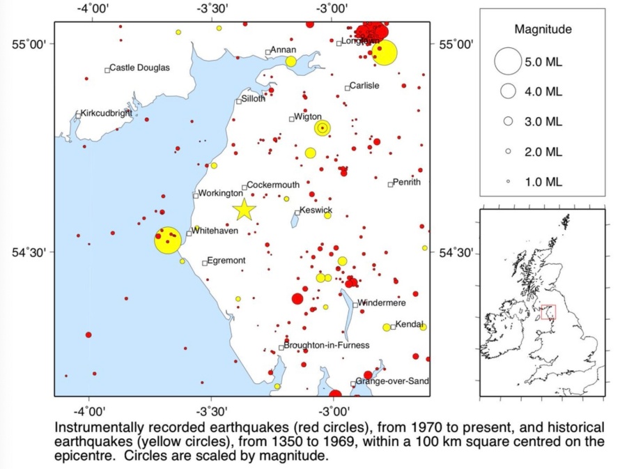
Whitehaven was at its zenith in creating the honeycomb of mines under the sea and land in the late 1700s. In 1786 there was an earth quake of magnitude 4.7 (or more) in Whitehaven which is above the baseline stated by Green and Bommer in inducing liquefaction. In 1996 Professor David Smythe wrote in New Scientist that “ The Whitehaven earthquake of 11 August 1786 islisted in the Nirex catalogue as magnitude 4.7, using a surface wave scale derived from macroseismic intensity data. In Mussons’s catalogue it is estimated as 5.0 (local magnitude). Its epicentre was only about 12 kilometres north ofthe Sellafield potential radioactive waste repository zone, and the focus was at a depth of between 5 and 15 kilometres. Even more worrying is the report of the Rampside or Barrow earthquake of 15. February 1865, which was about 40 kilometres along the geological strike to the. south. Although of small magnitude (2.2 or 3.0, depending upon the method ofestimation), its focus was extremely shallow—probably less than 1. kilometre down—and it pumped some 100 000 cubic metres of water to the. surface. This is a very rare occurrence indeed in the historical records, and is obviously of concern to those of us who wish Britain to select a radioactive. waste dump site which is supposed to be safe for at least 10000 years.”

Image: British Geological Survey
QUESTIONS
GEOLOGICAL DISPOSAL – THE FULL LIST OF UNRESOLVED SCIENTIFIC ISSUES ?
How many and what are the unresolved scientific issues with the experimental geological disposal plans for high level and intermediate level nuclear waste burial up to 1000 metres deep? Such as radioactive gas release within bentonite backfill, potential criticality due to overheating (over 100 degrees c), impacts of failed emplacements of containers, impact of seabed rise due to thermal heating ?
CUMBRIA- POLITICAL EXPEDIENCY VERSUS RECKLESSNESS
Sellafield holds the world’s largest stockpile of plutonium and nuclear wastes which makes Cumbria a politically expedient choice for a deep nuclear dump (Geological Disposal Facility) of high level nuclear wastes or a less deep dump (Near Surface Disposal) for intermediate level wastes. Either of these options would involve large scale mining acknowledged in historic and contemporary records as earthquake inducing.
What makes Cumbria politically expedient also makes Cumbria the most dangerous and reckless choice for the UK’s biggest infrastructure project of a new earthquake inducing mine or mines up to 1000 metres deep and approximately 26km square next to the the largest stockpiles of the most deadly radioactive materials on the planet. Plutonium is not classified as waste therefore not earmarked for a geological disposal facility ie it would remain on the Sellafield site.
BAN EARTHQUAKE INDUCING MINING NEAR THE SELLAFIELD SITE
Does the Environment Agency agree that deliberately inducing earthquakes with large scale mass void mining adjacent to Sellafield is reckless with regards to the survival of this and future generations of human and non human inhabitants of Cumbria and our European neighbours? Will the Environment Agency ban all mining creating mass voids in the vicinity of the Sellafield site? If not, why not?
EVER MORE LIKELY EXCEPTIONAL CIRCUMSTANCES WOULD MAKE THE LAKE DISTRICT (and BEYOND) A NUCLEAR SACRIFICE ZONE.
Does the Environment Agency have a duty to prevent the “exceptional circumstances” of a serious accident at Sellafield? The Lake District is within the Sellafield Outline Emergency Planning Zone. Will the Environment Agency ban all earthquake inducing mining in the vicinity of the Sellafield site? If not, why not?
Yours sincerely
Marianne Birkby
Lakes Against Nuclear Dump (a Radiation Free Lakeland campaign)
(address provided)
References:
Millom mine 600ft deep http://news.bbc.co.uk/local/cumbria/hi/people_and_places/history/newsid_8511000/8511193.stm
British Geological Survey – Historic Earthquakes in Cumbria https://x.com/britgeosurvey/status/968780345083654144
“The majority of the anthropogenic related earthquakes were caused by coal mining and the decline in their numbers from the 1980s to the 2000s was concurrent with a decline in UK coal production.”
Anthropogenic earthquakes in the UK: A national baseline prior to shale exploitation Wilson et. al. Marine and Petroleum Geology 68 (2015) http://www.sciencedirect.com/science/article/pii/S0264817215300751 Appendix A. Supplementary data Table 2. Subdivision of 1769 onshore events with ML ≥ 1.5 into natural (green), anthropogenic (coal mining – red, fracking – orange, geothermal – pale blue, potash mining – dark blue) and […]
Nuclear Safety – Sellafield Presentation by Steve Slater https://gnssn.iaea.org/main/Technical%20Meeting%20Nov%202018%20%20Nuclear%20Safety%20And%20Sec/Working%20Group%202%20-%20Nuclear%20Installations/10.%20Steve%20Slater%20-%20Presentation.pdf
Sellafield Outline Emergency Planning Zone https://cumbria.gov.uk/elibrary/Content/Internet/533/561/44148144041.pdf
